

Devastating wildfire across the Southern Plains during 2016 and 2018 resulted in significant economic and environmental losses, with the agricultural sector among those most affected. In order to better ascertain future risk to agricultural systems in this region from wildfires, following these events, the USDA Southern Plains Climate Hub coordinated a project with the NOAA RISA Southern Climate Impacts Planning Program (SCIPP), the University of Oklahoma’s Center for Spatial Analysis and the USDA ARS Grazinglands Research Laboratory, titled the 2016-2018 Southern Plains Wildfire Assessment. This project assessed the impact of the 2016-2018 fires, the past and projected influence of climate variability and change on wildfire occurrence, and the linkages to socioeconomic and environmental decision-making.
The project’s four objectives were:
- Review the meteorological, climatological, and land use causes of the 2016-2018 wildfires and assess future projections of wildfire occurrence in the region.
- Catalog the regional agricultural impacts of the wildfires, as well as USDA, a federal agency, and other organizational responses.
- Identify and highlight indicators of post-fire recovery at community, agricultural system, and/or ecological scales.
- Determine lessons learned, including the future risk of and vulnerability to wildfire occurrence and opportunities to inform and improve agricultural preparedness.
This assessment focuses on the three-state region of Kansas, Oklahoma, and Texas to address areas impacted by the Anderson Creek (2016) and NW Oklahoma Fire Complex (2017) wildfires, as well as surroudning regions. Additionally, several locally impacted cities were selected as host locations for on-site events held during the span of this project. The most prominent event was the 2018 Southern Plains Wildfire Forum held in Beaver, OK. Supplementary events included a pre-forum meeting held in Woodward, OK, a follow-up listening session held in Goodwell, OK, as well as others. The targeted individuals of these events included locally affected agricultural producers within the three-state region, key agricultural service providers, state agencies, and local officials. This assessment is a compilation of the materials, outcomes, and lessons learned during the duration of this project. This report also includes the summarized research findings that complements the key outcomes of the project. This project also included collaborations with additional organizations including the Redlands Community College and the National Integrated Drought Information System.
Access the full report here, or view select report sections below.
The 2018 Southern Plains Wildfire Forum was preceded by an introductory meeting held in Northwest Oklahoma during December of 2017, in which a handful of local individuals were invited to discuss topics and questions of interest to outline the upcoming forum’s agenda. Results of these discussions directly impacted the topics and presenters chosen for the forum and included topics such as weather conditions associated with wildfire and future implications, impact and recovery perspectives, management strategies to reduce future wildfire risk, and federal aid programs. Additionally, as the participants were heavily interested in an interactive forum with local perspectives on the topics above, such as having a prescribed fire panel, the forum agenda was adjusted to accommodate this desired content. Previous agenda items that were removed to make room for such panels included the supplementary research being conducted from the University of Oklahoma on vegetation recovery following wildfires. Therefore, a section on the goals, results, and findings of this research has been included at the end of this assessment report.
Of the topics suggested at the pre-forum meeting, the discussions of weather conditions associated with wildfire and expectations for the upcoming fire season were especially concentrated on and serve as a great explanation of the motivation behind the upcoming forum. Participants were interested in learning more about the science behind wildfire formation, the impacts of the El Nino Southern Oscillation, wildfire variability, and the weather variables conducive for wildfire. In order to support a broader depth of understanding on the motivation behind this project as well as on the content described in this assessment, these topics are explained in further detail below. A more in-depth explanation of this information was also presented at the February Forum.
The vulnerability of wildfire formation can be summarized by three primary factors highlighted in Figure 1: human interaction with the environment (ignition), land-use changes (fuel), and climate and weather conditions. Although these three factors are intertwined and are oftentimes complex, generally the increase of ignition sources and fuel supply, along with the appropriate meteorological environment, lead to the most conducive wildfire conditions.
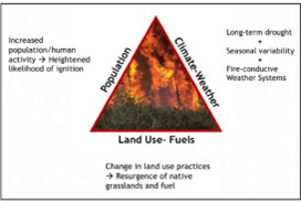
The Southern Great Plains has high vulnerability in all three of these factors which throughout history has made the region susceptible to fire and undoubtedly shaped the land. The largest source of wildfire ignition in the region is from the increased human interaction with the environment. The region has experienced an increased vulnerability from human activity in recent decades due to infrastructure development, notably train tracks, vehicles, and the most common ignitor, power lines.
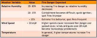
As land-use changes with human interaction, the management practices of the land also tend to change. Prescribed burns (a controlled, intentional wildfire for land management and risk reduction practices) were performed on Oklahoma lands dating back before early settlement, however, there has been a decrease in performance since the early 1900s. The reduction of these burns has allowed an increase of native vegetation growth and invasive species (such as Eastern Red Cedar which have large diameters and often create high-intensity fires) and has in return increased the vegetative fuels available for burning. The final factor, meteorological and climatological ingredients, is one of the most important factors that influence the onset, behavior, and fate of fires. Among short-term weather ingredients, the most significant indices for wildfire conditions are low relative humidity (dries fuel), wind speed and direction (can drastically impact fire containment), warm temperatures (increases evapotranspiration), and a lack of precipitation (reduces moisture of soil and dead fuel, and influences drought). It is characteristic of the Southern Great Plains to experience a flux of values for each of these indices, and when favorable conditions occur together, this leads to the most at-risk days for wildfire.
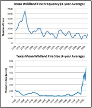
Wildfire intensity throughout the Southern Great Plains varies based on these factors and leads to altering intensities of wildfire seasons, with the highest number of wildfires occurring between January and April and the highest total acres burned occurring in March and April. An analysis from the Oklahoma Climatological Survey conducted on these variables over the period from 2002 to 2017 reveal that the 2016 and 2017 wildfires burned more acres in Oklahoma and Kansas than any other year during that time period. Additionally, no trend was found in an increasing annual wildfire count, therefore signifying a trend for less numbers of wildfires annually, but a larger amount burned when fire occurs. These findings match the trends of the U.S. wildfire data between 1980 and 2015 and a regional study on Texas between 1925 and 2011, with the latter represented in Figure 2. Both of these findings show a decrease in annual frequency of wildfires but an increase in acreage burned.
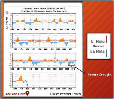
The El Niño Southern Oscillation (ENSO) is defined as the warm (El Niño) and cold (La Niña) phases of the Pacific’s sea surface temperatures that affect the position of the jet stream every few years. For the Southern Great Plains, La Niña usually leads to warm and dry conditions, which favors a more conducive fire environment by promoting higher temperatures and lower relative humidity. These impacts can often be felt most during winter, although effects can stretch from fall until spring.
During the late winter of 2018 when this information was provided at the Forum, the region was in a strengthening La Niña phase with warmer and drier conditions expected to continue into spring. As mentioned in the Formation of Wildfires section above, these variables are classified as two of the most significant indices for wildfire formation and they often correlate to a higher potential for ignition, fire spread, and large fire events (Vose et al. 2017). ENSO is just one example of the long-term climatological drivers of fire, with the other two consisting of dipole events (when a region experiences extremely dry to extremely wet conditions in one year) and drought. These three drivers all influence seasonal fluctuations of wet to dry periods and can help act as predictors of wildfire.
Associated with the climatological drivers that promote fire seasons, the set of weather variables that influences any given wildfire development include low relative humidity, high winds, warm temperatures, and low precipitation. The analysis of these variables across the Southern Great Plains over the last few decades show that there are thresholds for each variable that lead to the most conducive fire seasons. For instance, findings show that there is a strong correlation between years with a high number of low relative humidity days (less than 35%) and severe fire years. Additionally, years consisting of well above average spring temperatures and a recent shift from above average to below-average precipitation, correlate strongly with intense wildfire years. Ultimately, the years that tend to experience the most devastating fire seasons consist of all four of these conditions, such as what occurred in the spring of 2016 and 2017.
One of the most devastating recent Southern Great Plains wildfire outbreaks occurred on March 6, 2017 across portions of western Kansas and the panhandles of Oklahoma and Texas. Following the event in 2017, the National Weather Service (NWS) revealed that 32 major fires occurred and nearly 1.3 million acres burned. Further, a case study by Lindley (2018) explained that the ingredients of this outbreak followed high intensities of the three factors listed above and was described as “the perfect firestorm”.
Lindley further explained that this storm was unique in that it was an occurrence of multiple megafires, defined as fires burning over 100,000 acres (NWS 2017), and resulted in many high intensity, high damaging fires. There have only been 10 megafires documented over the Southern Great Plains in the modern era, which makes the 32 megafires during this event unprecedented. The most known megafire, the Starbuck fire, occurred on the border of Oklahoma and Kansas and burned over 660,000 acres (NWS 2017). The outbreak of these megafires drastically impacted individuals, property, and livestock, and exhausted resources from across the region. Strong local support was prevalent across the communities and bordering states, and various neighboring response personnel including firefighters, emergency managers, and burn associations offered their assistance in combating the events.

Click the image above to read the full report.
More wildfire information
Podcasts
John Weir, Oklahoma State Extension Fire Specialist. We visit about the recent Southern Plains wildfires, the need for more prescribed fires as a means to prevent new wildfires, and how the use of prescribed burning can help improve the landscape and benefit production agriculture.
Barth Crouch, Kansas Grazing Lands Coalition. We visit with Barth about wildfire vs. prescribed burning and the importance of managed fire as a tool to improve pasture and range health as well as reducing the danger from out of control wildfires.
Dr. Corey Moffet, ARS-Woodward, OK talks with us about wildfire and prescribed fire and how producers can utilize prescribed fire as a tool to get ahead of several natural resource issues including reducing wildfire fuel load.
Ken Salisbury, a farmer/rancher from Vici, Oklahoma about the impact wildfires have had on his operation. We also talk about what he thinks can be done to reduce wildfire risk.
Corey Jager, Legislative Liaison, Oklahoma Department of Wildlife Conservation. In this episode of the podcast, Corey talks with us about the department, their programs and focus, and how good land stewardship helps not just agriculture and the environment, but it also improves wildlife habitat.
Russell Stevens, Noble Research Institute Producer Consultant. In this episode, Russell visits with us about the work of the Institute, its interaction with agriculture producers and his work in helping landowners and others understand the importance of prescribed fire as a tool for range improvement and wildfire fuel reduction.
Mike Fuhr, State Director, Oklahoma Nature Conservancy. In this episode, we visit with Mike about the work of his organization, including their partnership with farmers, ranchers and other landowners to promote prescribed fire, soil health, and sustainable agriculture.
Prescribed fire demonstration – Concho, Oklahoma
John Weir, Oklahoma State University Extension Fire Specialist, presentation made in Watonga, Oklahoma bout the history of prescribed fire and how fire should be included in our natural resources tool kit. There are seven parts to his presentation and they can be seen here: Part 1, Part 2, Part 3, Part 4, Part 5, Part 6, and Part 7.
Laura McIver, Regional Rep. for Quail Unlimited/Pheasants Unlimited spoke to us at the Stillwater Field Day (9/18/21) about the event and how practices like prescribed fire help both with habitat improvement and wildfire suppression.
Karl Jett, Beaver County Oklahoma Conservation District Director spoke to us at their first Wildfire “Block Party”. This event was designed to help educate folks about the dangers of wildfire and what they can do to help better prepare for these disasters.