La Niña returns with warmer and wetter conditions on tap. Meteorological winter begins with near-record warmth and below-normal snow.
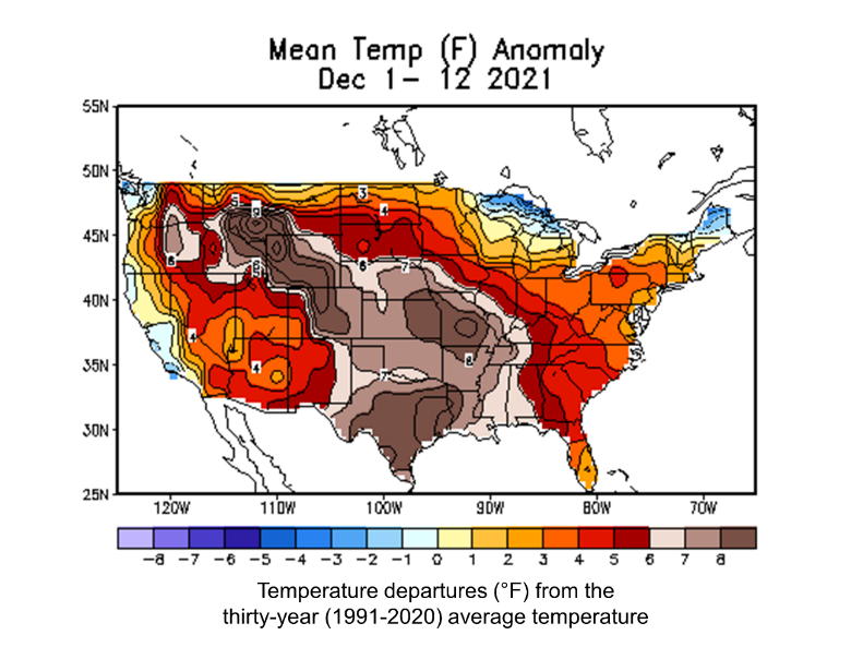
As the calendar shifts from fall to winter, many of us are probably wondering what the upcoming winter season holds in store for the Northeast. While meteorological winter officially began on December 1st, the weather across much of the region has been anything but winter-like. Temperatures in the Mid-Atlantic and southern New England have averaged 3-5°F above normal during the first twelve days of December. Only northern Maine and the northernmost parts of Vermont and New Hampshire have seen cooler than normal conditions. In these areas, temperatures have averaged 1-2°F below normal.
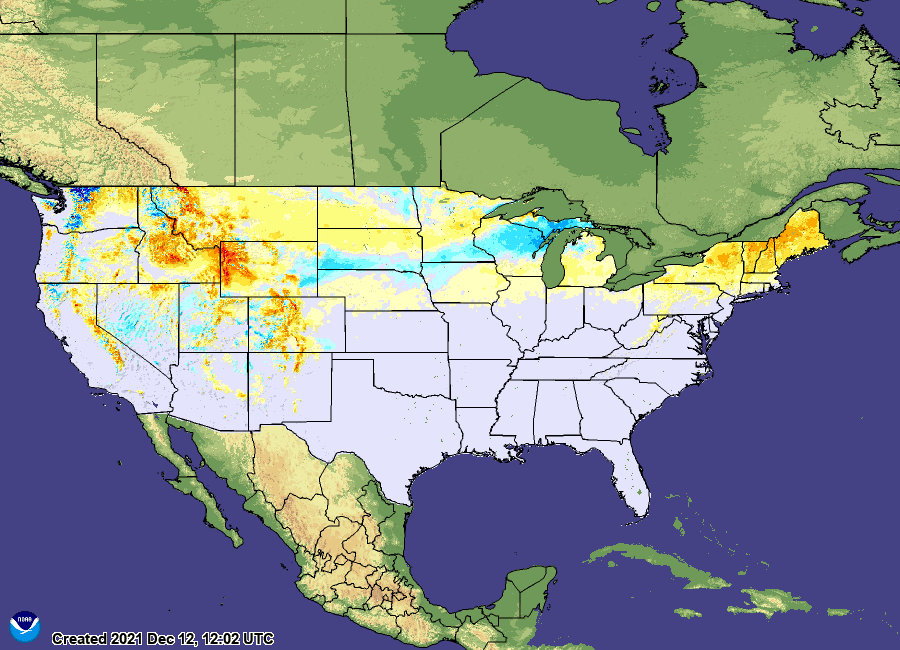
The absence of sustained cold in the Northeast has left the ground more green than white across much of the region. Areas along the Appalachian Mountains of West Virginia and Pennsylvania as well as much of New York and New England are seeing below normal snow depths for this time of year. As of December 12th, National Snow Analyses by NOAA’s National Weather Service indicated a near absence of snow cover in the Mid-Atlantic. Only the higher terrain of New York, Vermont, New Hampshire, and Maine had more than four inches of snow on the ground.
What is driving the early season warmth in the Northeast?
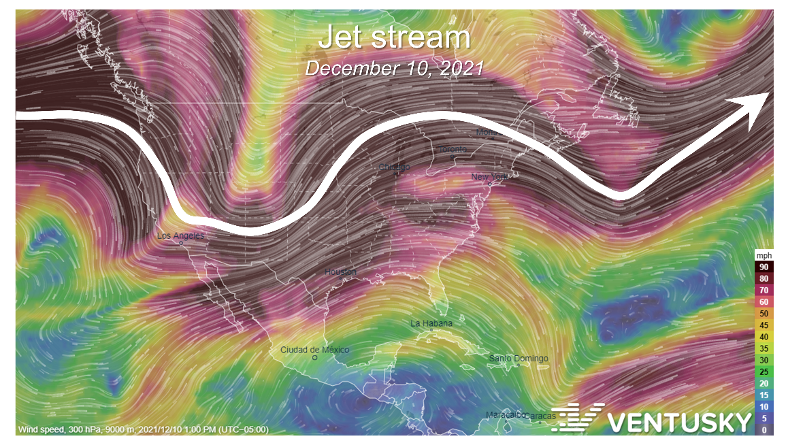
To a large extent, the springlike weather in the Northeast has been aided by the fast-moving river of air known as the jet stream. North of the jet stream conditions are colder and to the south, warmer. During the first twelve days of winter, the jet stream has frequently passed well north of the region. As a result, frigid air masses have mostly been bottled up in Canada. Cold spells thus far have been mild and brief.
Climate change is also playing an important role in the early season mildness. Long-term trends show that present-day (1986-2016) temperatures in the Northeast are 1.4°F warmer than they were during the first-half of the century (1901-1960). Moreover, the bulk of the warming is happening in winter. Minimum wintertime temperatures have warmed the fastest, with increases of roughly 1°F per decade since 1970. Against this backdrop, climate change is also shifting the balance towards extreme heat over extreme cold. In 2021, the Northeast saw 3.9 daily hot records for every daily cold record. During the first week of December alone, the ratio of daily hot to daily cold records was ten to one.
When will we see winter?
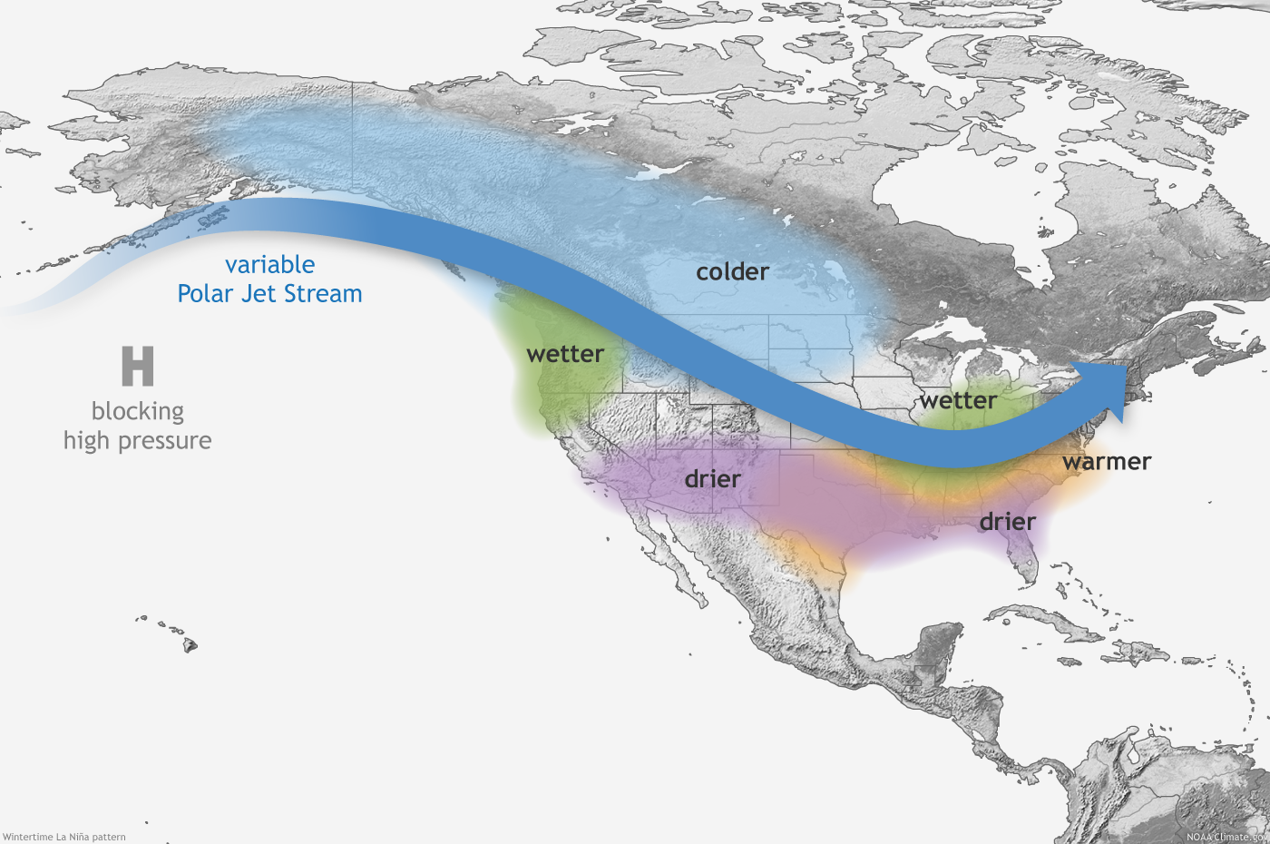
The outlook for the rest of the winter in the Northeast depends on a number of factors. Like last year, a moderate La Niña is expected to prevail during the winter months. Moderate La Niñas typically feature cooler and wetter conditions in the Northeast. Storms tend to track through the Great Lakes and northern New England favoring snowier than normal conditions across northern New York and western New England. In contrast, coastal areas and the Mid-Atlantic interior tend to see more rain and ice and less snow with storms passing to the north and west of the region.
Not all La Niña patterns are equal, however, and general expectations for the winter can be overridden by weather features that are difficult to forecast in the short term. Such was the case in mid-December of 2020 when a powerful Nor’easter developed off the coast of Virginia and tracked northward along the Atlantic seaboard. Despite the moderate La Niña, this major winter storm bucked the trend and produced record-breaking snowfall amounts for interior portions of the Mid-Atlantic and Northeast.
Through mid to late December 2021, NOAA’s Climate Prediction Center foresees a return to near-normal temperatures in the Northeast with a slight lean toward above normal precipitation. The longer term outlook over the next eight to fourteen days projects another round of above normal temperatures for the Mid-Atlantic and southern New England, with near-normal temperatures in northern New England. Precipitation is expected to be near normal through the end of December.
Looking further ahead, the latest winter outlook (issued on November 18th) leans warmer than normal for much of the Northeast. Meanwhile, wetter than normal conditions are expected along, and to the west of, the Appalachian Mountains. While the entire Northeast is predicted to see above-average temperatures this winter, the greatest odds for abnormal warmth extend from northeastern New York through New England. Even so, winter in the Northeast will not be entirely devoid of cold weather. Occasional outbreaks of cold air and winter precipitation should be anticipated throughout the season.