

Are long-range forecasts really any good? And can we forecast farther out than seven days with any confidence?
What’s the weather?
More often than not, we’ll greet each new day with some variation of this question to see if we’ll need to bring an umbrella to work, or if snow is likely to cancel school. As a topic, weather is probably one of the most popular conversation starters on or off the farm. And when we’re making advance plans for outdoor activities or field work, we often turn to the seven-day weather forecast to guide our decision making. But are long-range forecasts really any good? And can we forecast farther out than seven days with any confidence?
The answer to both questions is a resounding yes.
Numerical weather prediction (aka weather forecasting) has come a very long way since computer-based forecasts were first introduced in the 1950s. As Peter Bauer details in his article entitled, “Today's weather forecast: good with a strong chance of improvement,” the useful range of weather forecasts has improved by about a day per decade, meaning that today’s seven-day forecast is about as good as a one-day forecast in the 1950s. So despite what you might hear about weather forecasters being paid to be wrong 50% of the time, the reality is quite the opposite.
As weather forecasting continues its quiet revolution, forecasters with NOAA’s Climate Prediction Center (CPC) are advancing their ability to predict regional and global climate events that influence average weather (or climate) beyond the typical seven-day forecast. Among the most important events are El Niño and La Niña (aka the El Niño Southern Oscillation, or ENSO), which can foreshadow climatic conditions several seasons in advance, and the Madden-Julian Oscillation (MJO), which provides insight into the average weather we might experience in the coming weeks. When many different weather models agree on the nature of these climate features, reliable, long-range forecasts of temperatures and precipitation become possible. And knowing if the next two weeks will be warmer or colder than normal, or feature above- or below-average rainfall, helps industries like agriculture plan critical activities like fertilizing fields, as well as planting and harvesting crops.
How good are the long-range climate outlooks issued by NOAA’s CPC?
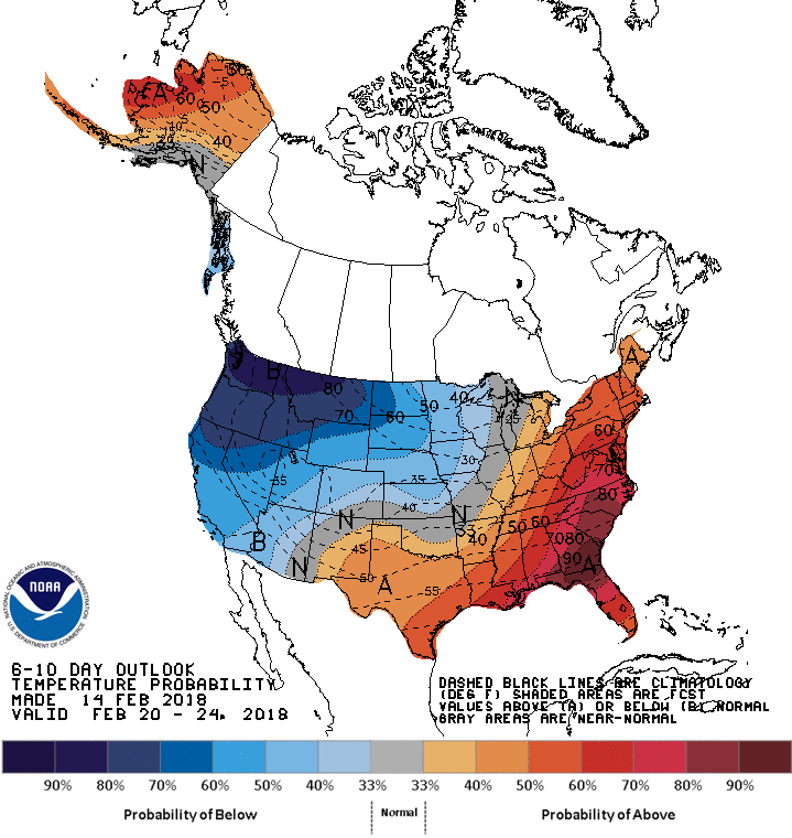
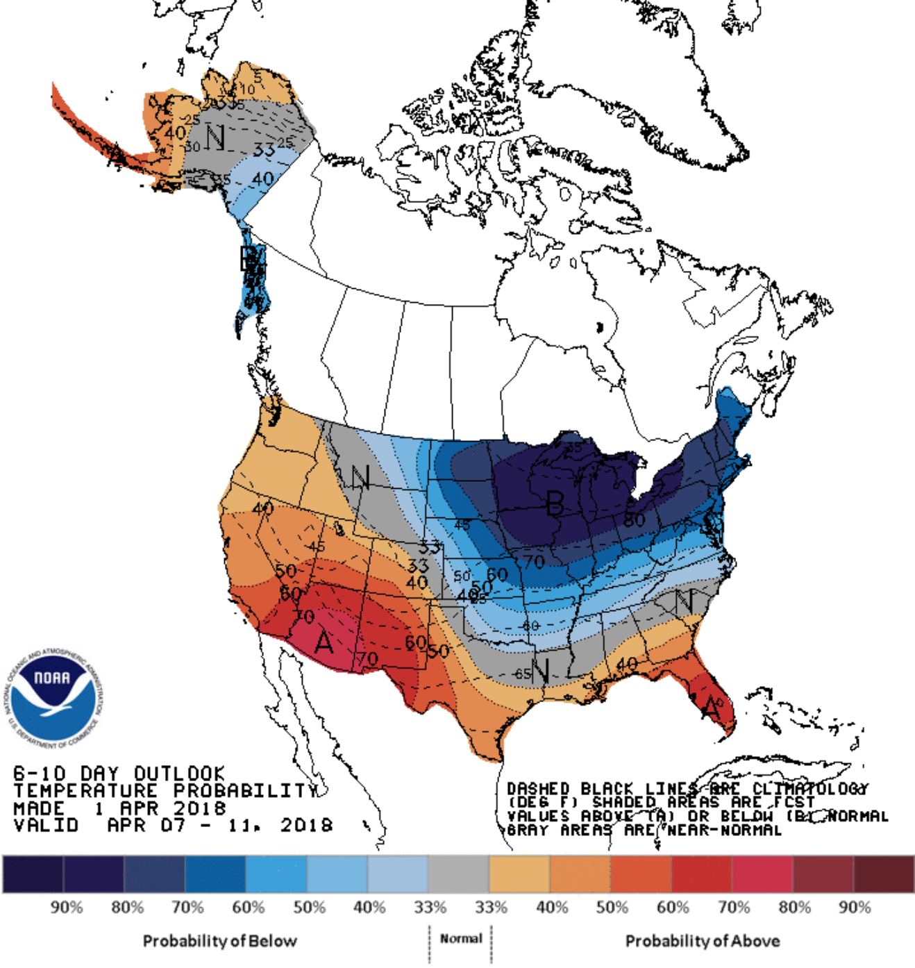
Quite good actually. Take the 6-10 day temperature forecast issued for the northeastern US on February 14, 2018, which indicated the likelihood of above-normal temperatures ranged from 40 to as high as 60%. Results from NOAA CPC’s Interactive Verification Web Tool showed the temperature forecast for mid- to late-February had very high skill, meaning it performed substantially better than random guessing. Similarly, the 6-10 day temperature outlook for mid-April, issued on April 1, 2018, also skillfully predicted that temperatures were likely to be much colder than normal during that time frame. In stark contrast, the outlook for most of May showed above normal temperatures. Those who were around the Northeast this spring, know that both forecasts turned out to be accurate.
So what’s the outlook for the next 6-10 days in the Northeast US? As of May 29, 2018, NOAA CPC foresees a moderate chance of below normal temperatures in our coastal areas and reasonable odds of below normal rainfall in the northern part of our region. The 30 day outlook for June shows above normal temperatures for most of the Northeast, and equal chances that precipitation will average above or below normal.
 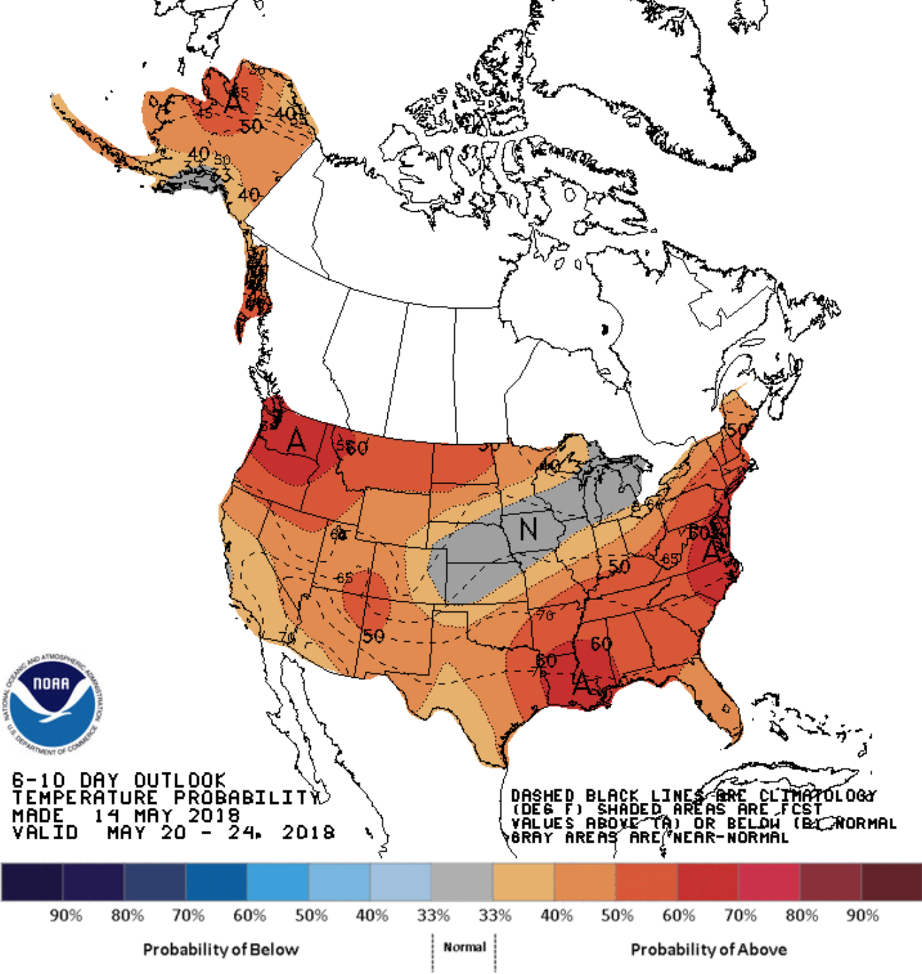 |
| NOAA CPC 6-10 Outlook issued on February 14, 2018 (left), and NOAA CPC 6-10 Outlook issued on May 14, 2018 (right) |
By Anthony Buda, Co-director, and Erin Lane, Coordinator