

What are Atmospheric Rivers?
Atmospheric rivers, as their name implies, are large channels of water in the atmosphere. They vary in size but can be 250–375 miles wide and over 1,000 miles long. Some carry more water than the biggest river on land, the Amazon River. Atmospheric rivers play important roles in annual water supplies around the world. These weather events supply 30–50% of precipitation and account for 90% of south-north water vapor transport for the U.S. west coast. In the northern hemisphere, this water transport usually starts in the south in the tropics and ends in the north. These storms were first defined by the term “atmospheric rivers” in the 1990s. Prior to that, the most famous atmospheric river in the northern hemisphere was often referred to as the “Pineapple Express” or “Chinook Winds,” and is still referred to that way. This particular atmospheric river pattern brings water from near Hawaii to the west coast of North America.
Unlike physical rivers, atmospheric rivers transport water as vapor rather than liquid. Also, high- and low-pressure systems determine where they move. This means that models can be used to forecast where they will drop their water, but it is not certain. Because the movements of an atmospheric river can be unpredictable, it can be difficult to prepare for their arrival.
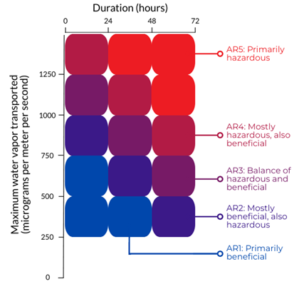
The Center for Western Weather and Water Extremes at Scripps Institute of Oceanography (University of California at Davis) has been working to better predict these storms to reduce damage. They also created a rating scale of atmospheric rivers in 2019. Like hurricanes and other storms, atmospheric rivers are given a rating of AR1 to AR5, with AR1 being “weak” or primarily beneficial and AR5 being “exceptional” or primarily hazardous.
This rating system and work by the Center for Western Weather and Water Extremes has allowed forecasters to alert planning agencies about large atmospheric rivers that may cause a lot of damage. This alert system was successful in California when an AR4 river (mostly hazardous, also beneficial) was predicted to hit the Big Sur coast. The warning allowed planners to close down highways, which ultimately saved lives when Highway 1 collapsed during the storm. In Washington, an early warning allowed the Washington Department of Transportation to close a highway that had high avalanche danger in November 2022.
Atmospheric Rivers in the Northwest
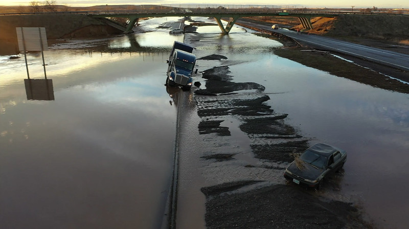
Atmospheric rivers are a natural part of the water cycle in the western U.S. and in the Northwest occur most often in the fall and winter. When they are beneficial, they bring much needed rain to the region. Between 1950 and 2010, between 60 and 74% of persistent drought ended when atmospheric rivers made landfall. Although these storms can be helpful, when they bring too much water at once, they can cause a lot of damage. In the Northwest, atmospheric rivers have been the cause of recent events that had catastrophic impacts for communities, from flooding in Alaska to mudslides in Oregon, among others. Atmospheric rivers have been causing this type of damage for years. Historically, these systems have been associated with 80% of all flooding damage on the West Coast (including California). This causes about $1 billion of damage every year.
The Future of Atmospheric Rivers with Climate Change
As human-caused climate change continues to warm the planet, the number of days that the western U.S. will experience atmospheric rivers is projected to increase. Atmospheric rivers are also expected to be bigger and more hazardous on average. As climate change warms the air and oceans, these storms will have more fuel to become larger and stronger because a warmer atmosphere can hold more moisture. Some research shows that they are expected to be 25% longer and wider, meaning more rain over more area for longer. Therefore, heavy rainfall and extreme winds caused by these rivers will increase. This also means that the number of atmospheric rivers that cause damage will increase.
Several factors affect how much damage will be caused by future atmospheric rivers. Estimates show that by 2090, these events could cause between $2.3 and $3.2 billion of damage every year. As rainfall increases, soil will not be able to absorb the additional water. This will cause increased runoff, which could overwhelm rivers and cause flooding. It could also lead to mudslides.
In addition, the size and frequency of wildfires in the Northwest will increase with climate change. Wildfires burn the vegetation that stabilizes hillsides, which increases the chances of mudslides. One study suggests that by 2100, the Northwest may see up to a 7-fold increase in instances where extreme rain events follow periods of high wildfire danger within the same year.
Knowing how atmospheric rivers will increase in frequency and intensity with climate change is important for planning. Understanding the future of atmospheric rivers will help in watershed planning. Adding climate change considerations into forest management plans, for example by replacing undersized culverts and removing unnecessary roads, will help decrease the negative effects of large storms and flooding on infrastructure. For public safety, it will also be important to stabilize vulnerable hillslopes and protect or close certain roads, especially during these events. Using models to project atmospheric river intensity will help emergency crews prepare and communities reduce their vulnerabilities, which will ultimately save lives and help reduce the damage these events will cause.
A few notable storms that have been attributed to atmospheric rivers:
- West Coast, December 1861-January 1862. In California, flooding in Sacramento forced the state capital to move temporarily to San Francisco.
- Washington, November 5-7, 2006. Mt. Rainier National Park was forced to close during a storm that dropped 18 inches of rain in 36 hours, causing $36 million in damage
- Alaska, September 2012. Two atmospheric rivers in the month of September dropped over 50 inches of precipitation, resulted in one fatality, and caused $35 million in damage.
- Southeast Alaska, December 1-2, 2020. Parts of the region received 99 inches of snow or 20+ inches of rain during this event.
- Oregon, January 11-13, 2021. This AR5 (primarily hazardous) saturated soils and caused a landslide on I-84/US-30 in Oregon and SR-14 in Washington. Residents of Dodson, OR were told to evacuate because of potentially life-threatening flash floods.
- Alaska, June 24-26, 2021, which may have been linked to the 2021 heat dome.
- Oregon, Washington, and British Columbia, November 10-16, 2021. An atmospheric river brought about 12 inches of rain concentrated in the Seattle, WA and Vancouver, BC area over six days. This event occurred shortly after months of wildfires and led to landslides, flooding, and saturated soils across the region.
- Oregon and Washington, January 6, 2022. Rain on snow led to flooding concerns in Oregon and Washington, and several roads were closed for safety reasons.
Additional Resources
- Center for Western Weather and Water Extremes – predictions and storm analyses
- NOAA’s Atmospheric River Portal
- Emergency Watershed Protection | Natural Resources Conservation Service
- Watershed and Flood Prevention Operations (WFPO) Program | Natural Resources Conservation Service
Related Topics:
-
A summary of current and expected impacts due to climate change in the Northwest.
-
Restoring functioning watersheds in Washington helps national forests adapt to changing snowpack and streamflow.
-
The 2021 heat dome caused record-breaking temperatures in the Northwest. Climate change increases the likelihood of heat waves like this.