

Estimated reading time: 8 minutes
Key Points:- Global climate models are computer programs that consist of several hundred thousand lines of code. They calculate the interactions between the ocean, atmosphere and land using factors such as water vapor, carbon dioxide, heat, and the Earth’s rotation as inputs.
- Climate models project climate (the average weather over a long period of time, e.g., a 30-year period), not weather (what an area experiences on an hourly or daily basis).
- Climate model outputs are very coarse, or low resolution. To see outputs at a more local scale, you must look at the downscaled version of the model.
- Models help us understand how our actions can affect the future climate. They allow modelers to look at different scenarios of increased greenhouse gas emissions and see how those increases may affect the planet.
What are models?
Scientific models are mathematical relationships or equations that explain how a system (group of interacting or interrelating elements) works. These mathematical relationships can help to project how a system may respond in the future. Modelers use observational data to understand how different parts of systems interact with each other. They then use this information to project responses under other conditions, including future ones.
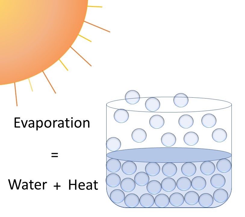
Models help us to understand a variety of systems. They could be as simple as a model of evaporation. When the sun’s energy heats water, that energy is transferred to water molecules and the water evaporates. By studying this process, scientists can observe predictable patterns and translate those patterns into equations that can be used to model this process in other situations. Models start with the initial condition of the system (i.e., the water’s initial temperature), add inputs (i.e., heat), calculate how the inputs and initial condition interact, and produce outputs (i.e., evaporation).
What are climate models?
Climate models ― also called General Circulation Models, Global Climate Models, or GCMs ― are more complex than a model of evaporation, but they follow the same general idea. These models use many different factors such as water vapor, carbon dioxide, heat, and the Earth’s rotation as inputs. Computers then calculate how these factors interact with the ocean, air, and land. Climate models are computer programs that consist of several hundred thousand lines of code. Each model is created by a modeling group, which consists of many scientists and computer programmers. The output of these models is a projection of how the Earth’s climate may change.
To better understand what global climate models project, it helps to understand the difference between weather and climate. In general, the west side of the Cascade Range typically experiences a cool, wet winter. This is climate. Climate is usually averaged over a long period of time (e.g., a 30-year period).
Weather, on the other hand, is what an area experiences on an hourly or daily basis. It is the instantaneous physical state of a location and can include the current temperature, wind, humidity, and precipitation. For example, Portland, Oregon can suddenly get an unexpected spell of warm, dry conditions in January. This may not be what was expected, but it is not outside of the range of possibilities.
Climate models project the climate, not the weather. They cannot say that on October 24, 2050, it will rain in Seattle. They can say, however, that in 2050, average winter conditions in the Northwest are likely to be warmer than they are in the present day.
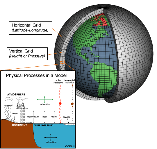
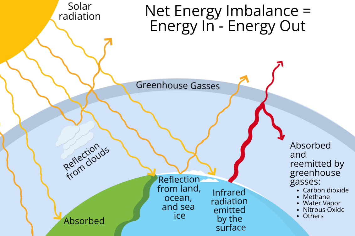
Once we understand what climate models project, we can look at how they create these projections. Climate models calculate the physical interactions between four components: atmosphere, land, ocean, and sea ice. The calculations are based on several inputs: air temperature, pressure, density, water vapor content, and wind magnitude.
The size and complexity of the Earth make it challenging to represent in a model. This is in part because different places on the planet have different responses to energy and materials (e.g., land warms up and cools down faster than oceans). It is also because different parts of the planet have different climate influences (e.g., jet streams are typically stronger at the poles than they are at the equator). To make this task more manageable, climate models divide the Earth into a 3D grid with cubes extending across the surface of the Earth, up into the atmosphere, and down into the ocean. Each cube is analyzed individually over time while receiving information (inputs) from and passing information (outputs) to neighboring cubes. The size of the cubes varies among models, but each cube is approximately 100 km3 (24 miles3, about 2.8 miles on every side of each cube). How high and how deep the cubes extend also varies among models and depends on what information is of most interest to modelers . Like pixels in a photograph, a higher resolution model has more, smaller cubes and provides a more accurate picture of how changes to the climate impact an area. A 3D grid helps reduce errors because each grid cell can have different inputs, outputs, and calculations for different terrains (i.e., rainforests versus deserts, or open ocean versus coastal ocean) and atmospheric layers.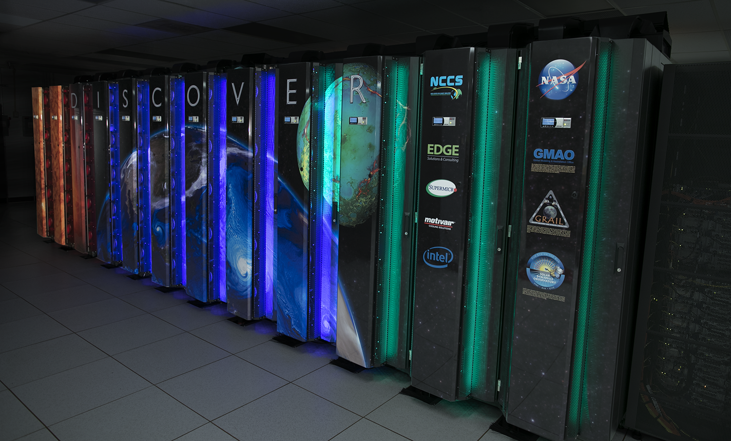
Some variables and processes, such as snow, rain, and clouds, only exist and/or function in areas smaller than the typical climate model cube (100 km3), and must be simplified, or parameterized. Parameterization includes other mathematical equations that mimic real-world impacts. Parameterization may be used to estimate how much sunlight is reflected or absorbed by clouds, and how much heat is radiated by them, what types of clouds exist in each cube, and when and which type of precipitation forms.
Climate models have become more advanced over the past several decades. Earlier models calculated physical processes for the atmosphere, land, ocean, and sea ice components separately. As models improved, researchers coupled the ocean and atmosphere components into one model, which more accurately represents Earth’s climate. Earlier models had very coarse resolutions (500 km3, or 119 miles3, about 5 miles on every side of each cube). They showed regional detail, but the resolution was not good enough to provide meaningful local climate information. Improvements in computing power allowed models to be run at higher resolutions, providing greater spatial detail. Despite advances in technology, only very large supercomputers are capable of handling high-resolution climate modeling on a global scale.
Downscaling Climate Models
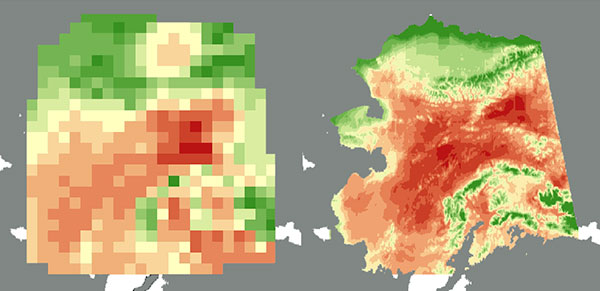
In order to produce climate projections at more local scales (less than 100 km3), models are “downscaled.” There are two methods of downscaling: dynamical and statistical. Dynamical downscaling uses the output of global climate models as the input for finer scaled regional climate models that recalculate climate at a finer scale using local features. For example, in the Northwest, regional climate models provide more detail on the topographic complexity of this region, such as the differences in what will happen at the top of Mt. Hood versus at the bottom of Mt. Hood. Statistical downscaling uses statistics to show how large-scale climate patterns affect the local climate. Keep in mind that when models are downscaled, they do not become more “accurate” or better than global climate models, just more detailed.
What do climate models tell us about climate change?
Models help us understand how our actions can affect the future climate. They allow modelers to look at different scenarios of increased greenhouse gas emissions and see how those increases may affect the planet. The main outputs of climate models are temperature, humidity of the different layers of the atmosphere, and precipitation (rainfall and snowfall). Models also provide information about the ocean, including temperature, salinity, pH, and extent and cover of ice sheets.
The outputs from global climate models are used as inputs into other models to understand what will happen to natural resources. Changes in temperature and precipitation projected by climate models are used by other types of models to calculate the effects on snowpack, crop production, forests and woodlands, and rangelands, among other applications.
In the Northwest, all models project that temperatures will increase. Precipitation projections are less certain, but a majority of models project a slight increase in precipitation, with wetter winters, drier summers, and more extreme precipitation events.
How accurate are climate models?
All models, including climate models, contain some level of uncertainty. This is largely because the complex behavior of certain atmospheric processes is difficult to replicate. Some of these processes are chaotic in nature, such as turbulence, which has been referred to as “the most important unsolved problem in classical physics” and is nearly impossible to model. Others occur at such small scales, such as how clouds form, that models cannot perfectly capture their behavior. When models are parameterized, they attempt to incorporate these atmospheric processes into models, but they are never 100% accurate.
Different models are parameterized differently. Therefore, there is often variation among model projections. Since no model is perfect, it is important to pay attention to both the range and general consensus of all models. For this reason, each model’s projection is typically referred to as a “plausible future.” Depending on how the atmosphere responds or how human behavior changes, the climate could go down any of the paths that models project. If all models agree on the same changes, that is the most likely outcome.
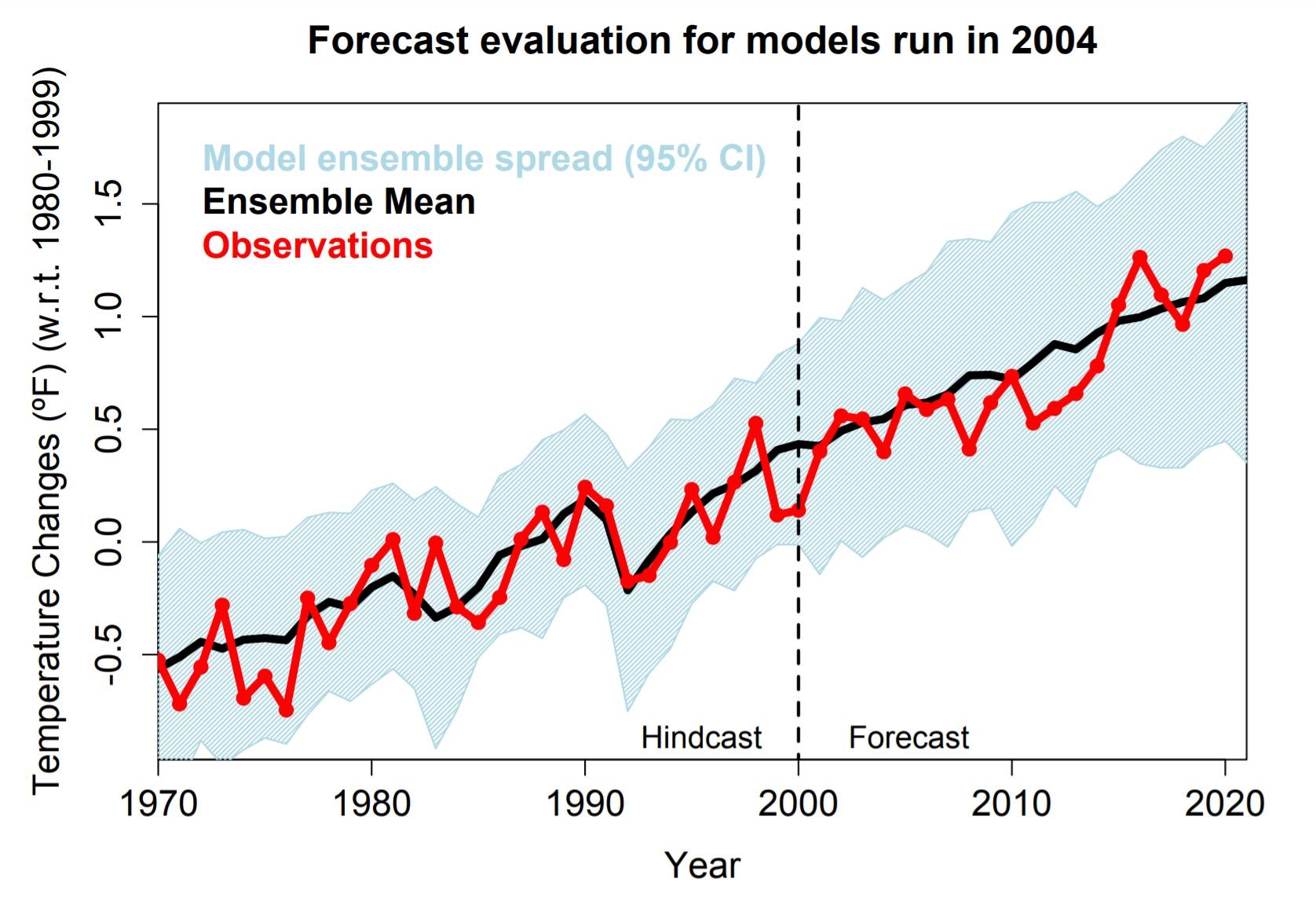
Despite the level of uncertainty and variation between models, studies are showing that models have been accurate in their projections. Climate models are evaluated for accuracy by “hindcasting,” or replicating the climate of the past 100 years. Because models have been run since the 1990s, scientists can now see how accurate earlier models were at projecting future changes. Observed changes in temperature and precipitation have generally been consistent with the changes projected by earlier models. The accurate projections of future climate and hindcasting of past climate makes us confident that models can reliably project changes in the climate.
The future of climate models
Climate models are limited by computing power and the availability of climate data. As technology, computer science, and availability of climate data improve, so will models. These improvements may help to reduce some of the current problems climate models face, like uncertainty, accuracy, and resolution.
More and better observational data on the atmosphere and oceans will aid in improving models. Data from certain parts of the planet are lacking, such as from the open ocean. Enough data exist to make robust projections about the climate, but more data would improve models. Without enough observational data, scientists don’t know exactly what outputs should look like. This makes it hard to know if a model is wrong, why a model is wrong, and how to improve it. Also, climate models are currently based on observed data from the past few decades. However, the Earth's climate is constantly changing, so it is important to use more recent data to create models. With more information, we can understand what changes are happening in the present climate, and how that climate will change in the future.
Improvements to computing power will also improve models. As computers become more advanced, models will be able to output information in finer detail. Higher resolution models tend to perform better in model evaluations, so being able to run models with higher resolution will improve projections. They will also be able to take less time computing, making them more efficient. Models could test more scenarios more quickly. They could also incorporate updated science as it is released, rather than waiting for long periods between model phases because model runs are expensive and can take months. This means scientists and policy makers could have more up-to-date information when using climate projections to plan for the future.
Unfortunately, improved computing will only help to an extent, as we still cannot replicate the Earth system perfectly. To aid in better understanding of the Earth system, recent studies have started using artificial intelligence and machine learning to improve models. Machine learning techniques can help scientist improve climate models faster by more efficiently analyzing data and identifying patterns. The information these techniques reveal could be used to improve the climate models by improving their representation of processes such as cloud formation and turbulence.
More advanced models will help us better understand climate change. With better understanding, we will be able to plan and respond to the ever-changing Earth system and reduce some of the negative impacts of climate change.
-
What are climate model phases and scenarios?
-
FAQs about climate models

- Downscaling methods:
- Dynamical (video)
- Statistical (video)
- The White House's Guide for Selecting Climate Information to Use in Climate Risk and Impact Assessments
- Map of CMIP6 Modeling Groups
- List of CMIP6 Modeling groups
- USDA Climate Change Resource Center
- Pacific Northwest Climate Projection Tool
- Climate Model Resolution
- Timeline: The history of climate modelling
-
Climate Change Impacts in the Northwest

A summary of current and expected impacts due to climate change in the Northwest.
-
Alaska and a Changing Climate

Rapid warming and changing precipitation patterns in Alaska affect communities, industry, and natural resources.
-
Northwest Vulnerability Assessments

Vulnerability assessments for agriculture, forestry, rangelands, and Tribal Nations in the Northwest.